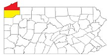
Erie–Meadville combined statistical area
Place in Pennsylvania, United StatesThe Erie–Meadville, PA Combined Statistical Area (CSA) is made up of two counties in northwestern Pennsylvania. The United States Office of Management and Budget has recognized the Erie and Meadville areas along with the counties of Erie and Crawford to make a Combined Statistical Area, located in northwestern Pennsylvania. Though these county line boundaries are rather arbitrary since Erie serves as the regional hub for the bordering areas of southwestern New York and northeastern Ohio, including the cities of Jamestown and Conneaut.
Read article
Top Questions
AI generatedMore questions
Nearby Places

UPMC Park
Baseball park in Erie, Pennsylvania

Warner Theatre (Erie, Pennsylvania)
Theater in Erie, Pennsylvania

Roman Catholic Diocese of Erie
Diocese of the Catholic Church

Union Station (Erie, Pennsylvania)
Railroad station in Erie, Pennsylvania

St. Peter Cathedral (Erie, Pennsylvania)
Church in Pennsylvania, United States
Erie Playhouse

Renaissance Centre (Erie, Pennsylvania)
Office building in Pennsylvania, United States

Lovell Manufacturing Company
United States historic place


